Followers

Monday, June 30, 2008

June 02 2007 McLeod county

Found this video on Google:


Does anyone else remember this day?


If I recall, this was a closed low setup where a sheriffnado/funnel report caused just about every spotter downstream to see rotation in anything dark.

Sunday, June 29, 2008

Atomic Twister - Monticello Style


OK...I was always under the impression local Skywarn spotters were supposed to be pretty familiar with the terrain and the topographical oddities of the area in which they live and report. So, can someone explain to me what a Skywarn spotter near Montricello MN was doing reporting a wallcloud and funnel over Monti nuke plant on Friday? For crying out loud, we see the steam coming off the cooling ponds 365 days per year and sure as shit, every year someone will make a shit report as the steam get caught in the updraft of a rain shower or a shelf cloud. It happened again 6-27-08. Thank goodness net control for West Metro Skywarn is familiar with this problem and immediately discounted it as a bad report.

So, what are your opinions of Skywarn? Seems to me they are talking more steps backwards in accurate reporting than getting better (even with limited experience). Instead of going off on a rant about my opinions, I'd love to hear some of yours. I really want to hear from the southern chasers who get to see GOOD supercells and not the crap rain wrapped HP's up here. Do RFD plumes get reported as torns? Do Skywarn spotters have such a hard time telling the difference between a shelf cloud and a REAL wall cloud as the spotters have up here?

Time to get some stock video ready for the Discovery Channel...

Friday, June 27, 2008

Benton County tornado warned storm

This cell was pure OUTFLOW CRAP. As Cullen and I watched the SHELF CLOUD come at us north of Foley, MN and the tornado warning came out, once I again I let loose with a WFT???!!! rant. You guys who really know what a tornadic cell looks like know tornadoes don't come from this:
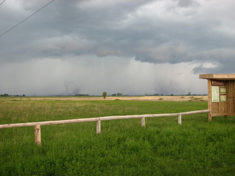
So, even after calling MPX and letting them know the storm was totally outflow dominant, evidently some super spotter or someone better trained in the use of a taser managed to keep this junk torn warned. Rad vel scans showed NO organized rotation but...

while Cullen and I were at this location:


Looking at this:

A funnel report came out. WTF????!!!! I WILL PROVIDE A $50 TIMBERLODGE STEAKHOUSE GIFT CERTIFICATE TO ANY BENTON COUNTY SKYWARN SPOTTER OR SHERIFF'S DEPUTY WHO CAN PROVIDE A PICTURE OR VIDEO OF A BONA-FIDE TORNADIC FUNNEL FROM THIS STORM. I am done reporting. It makes no difference. This cell got re-warned after this! Hats off to the NWS people who deal with all the crap reports which come in then have to deal with the media backlash of the public becoming immune to the warnings. Going to a Skywarn class every other year up here and watching a video evidently only makes you qualified to make an educated 50-50 guess as to what you are seeing. I know damn well this was another case of "there is a tornado warning so I am going to see a tornado".

I felt really bad for the older couple on highway 95 east of 25 who had gotten out of their vehicle and were standing in the ditch waiting for the tornado to happen. I did stop and let them know it was safe to continue on to the west but to be careful as there would be heavy rain and some minor gusty winds. They seemed rather irked there was a tornado warning for nothing. This is what was going over at the time:
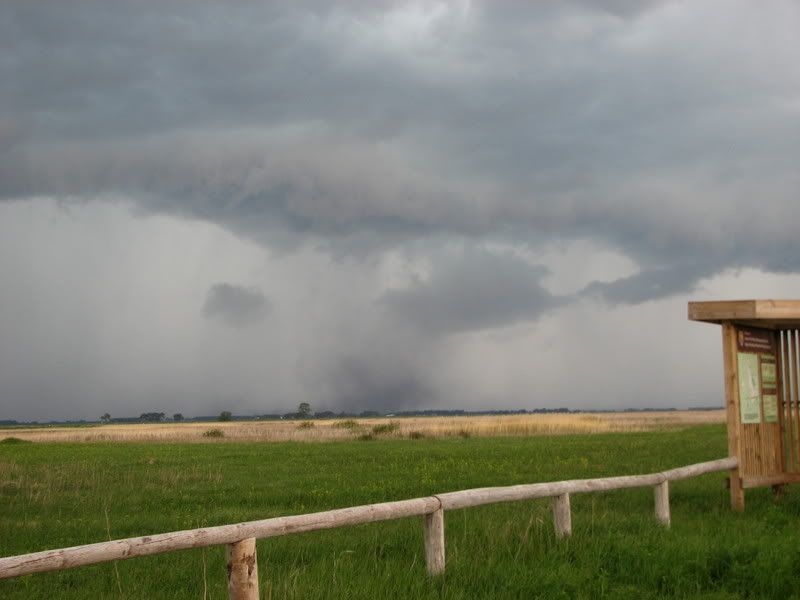
Pretty bad...even for a whale's mouth.

Question for some of the NWS people who read my blog. What criteria is used to issue a tornado warning for a linear storm complex? There was a "inflow notch" of sorts on the line briefly, but nothing to indicate an area of organized rotation on any of the velocity scans. So what gives? I'd like to know as the answer I got from the WCM of a different CWA giving a gustnado the distinction of being "a leading edge suction vorticity" (and an EF1 at that) evidently can be decoded into three letters....CYA. So what gives?

Rant mode off...

Saturday, June 21, 2008

Buffalo MN PRCA rodeo

Running a little behind as it has been a really busy past few days around here between activities, company, chasing, and getting projects around the house done. More pics can be found in my photo album.


Melinda, her dad, step mom, all the kids less Matt (who is still in France for another week) and myself all went to the Buffalo Rodeo on Thursday night. It was a total blast and I can't wait to go to a couple more this year at least.


From a photography point of view, it was really challanging as the light was weird. With the setting sun, everything red wanted to over saturate and anything white or yellow wanted to turn orange.


The other issue was the vapor lights they use at night. To the eye they work to see clearly, but the camera didn't like the faster shutter speeds even at ISO 1600. This was using the f2.8 70-200mm lens. Not a chance of using a teleconveter as the speed at which the action happens was nearly impossible to get at anything over f4.0.


The cowboys and the stock are amazing athletes.


The photo above was a re-ride for a bullrider where I was able to get down close into an area there was no way I could have during the main show. Good example of the issue with the lighting and using a higher ISO. This was 1/100 sec at f2.8.


Same here. Under the lights at f2.8 1/100 sec. Barrel racing is hard to shoot with poor lighting as they are so fast coming around the corners.


The rodeo is Melinda's gig and I am really glad she got me out there. One more thing we can enjoy together!

6 20 08 Minnesota storms and the driveway is done...again

Timed sealing the cracks on the driveway before seal coating it with a round of pretty robust little storms yesterday afternoon. Kept watching the boundary eeking its way into western MN near the hump where the winds were a little better. By early afternoon a small cu field developed and some light showers soon followed. As they moved east/southeast into better instability and some better shear, a decent multicell cluster made their way into eastern Kandiyohi county moving southeast. Parked myself north of Howard Lake, MN and tried to pick the best looking one as they came towards me.


One cell developed a pretty fair forward flank updraft base with the core falling more north of it so decided to stick with this one. As I neared Buffalo, a nice gustnado formed under the base as the line of cell began to rapidly implode sending a gust front rocketing off to the southeast.


This gustnado lasted about 10 minutes and churned itself off to the east. Although I never let it overtake me, I did measure a wind gust of 47.5mph with it as the most vigorous area stayed just to my north. Called MPX and let Karen know who issued a special weather statement as it merged with the gust front and headed towards the lakes on the west side of the Minneapolis metro area.


As I poked around where the gust from and gustnado merged, I found a group of town homes with some shingle damage and some 3"- 4" tree limbs down. I stopped and talked to some kids who were playing when the gust hit. They showed me their tampoline which was tossed about 50 feet and said some type of light fixture up the street was also blown down.

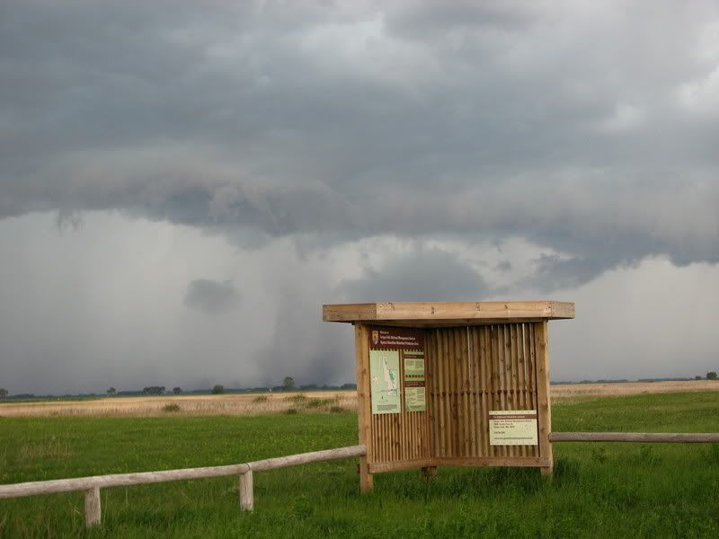
One last look off to the east at the backside of the storms as they moved off to the east towards the Minneapolis metro area.

And I still managed to get the driveway done.

Friday, June 20, 2008

Pretty storms later today?

Between sealing the cracks in driveway (gotta love Minnesota and the freeze-thaw cycles) and going through almost 300 photos from the Buffalo Rodeo from last night, keeping an eye on a couple of weak waves coming down from the northwest. The wave last night didn't do much as the best cell puked about a county and a half away so no lighting photo ops. Jessica still hasn't gotten to go out and look at a storm with us so maybe today will be the day.

Here is a teaser photo Cullen took at the rodeo last night. Many more will be posted on line soon. Click to enlarge.

Thursday, June 19, 2008

Baby bald eagle

Decided to see if I could see any of the eaglets on a couple of the bald eagle nests I've been watching this spring. About a quart of blood later and I hope I don't die from West Nile Virus, one kind of cooperated. Had to keep out a wary eye from mom and dad coming back to chase me away but this little guy decided to pop out of the nest for a few minutes to see what I was up to. Click on the images to enlarge.


Wednesday, June 18, 2008

Kids and fishing

Taking a few days off from chasing to spend some time with the kids and get some things done around the house. Kind of kicking myself for not heading out to the Badlands or Valentine, NE area yesterday as I am sure the storms were beautiful.

Anyhow, the kids and I headed out to a lake with a ton of sunfish just to spend a lazy in the sun. The only competition we had for the fish was this female bald eagle who kept a close watch on us from a far distance.

Cailyn pulling in one of about a gazillion pumpkin seeds and bluegills they caught.

Jess got the big fish of the day award with her bass.

Cullen once again ends up being the subject of one of my artistic attempts.

Tuesday, June 17, 2008

Gone to the dogs

Here are some pics from last Saturday. Melinda had class and Jess and Matt were at their dad's so Cullen, Cailyn and I took in the dog frisbee competition for a couple of hours . These dogs and their handlers were a blast to watch!


Monday, June 16, 2008

6 14 08 Update

Per an email I received from the WCM at FGF, the "So my inclination is to call that EF1... an overly zealous gustnado, basically a suction vortex on the leading edge of the shelf cloud."

Sigh...I guess so. Afterall per answer.com, the definition of a tornado is: "A rotating column of air ranging in width from a few yards to more than a mile and whirling at destructively high speeds, usually accompanied by a funnel-shaped downward extension of a cumulonimbus cloud." Note there is no funnel needed to still meet the rotating column of air portion of the definition.

I'm going to go back over the data from the May 9th 2004 Mother's Day even in MN. I believe there was an F1 associated with that setup which was an almost duplicate to this past Saturday. Maybe I need to spend some more time researching this type of tornado as I may have missed a few hundred in my career.

More bad reporting on 6-14-08

A high school classmate of mine, Bill Folger, was in Fergus Falls on June 14th and got some good pics of the gustnado which was reported as a tornado. I will be sending pics to Greg Gust who is the WCM at FGF so the LSR can be corrected. This is so obviously not a tornadic circulation.


Sunday, June 15, 2008

June 14th central MN bow echo and supercell

Well that was interesting. I knew there were storms popping in a severe box out in western MN by about 4 pm. Checked the radar and didn't think there was much chance of the line accelerating until later in the evening so we headed to the Buffalo Days parade as soon as Melinda got home from class. About 25 units had gone through when my mom called from Fergus to say they were under a tornado warning and she was heading out to see. She called back to say it was nothing but a shelf cloud complete with shark's teeth and a few gustnadoes. Sure enough, one of them got reported as a tornado and made in on FGF's LSR report. Nice. Here we go again with the bad reporting syndrome. Little did I know it was going to get worse this evening in my own area. Eric Whitehill and Nick Elms both called to let me know the line was starting it's southward plunge and accelerating so we bailed on the parade and headed west to north of Darwin, MN as a tornado warning was being issued for Meeker county based on a spotter report of a tornado near Grove City and moving southeast at 60 mph. Hmmmm.

Here is the "tornado":


and the SHELF CLOUD it was under. Nice gustnado but definitely not a tornado and not worth sending people scrambling to their basements thinking they might die. At this time my 2M ICOM radio failed and I was unable to contact net control with updated information as to the situation....and I left my cell phone at home! Yep, I'm about as worthless of a spotter as there is sometimes.


A classic case of a spotternado and not taking time to think about what they are seeing. I'm sure this was the cause of what was to happen next as the bow moved downstream into Wright county. I heard a mobile spotter report a segmented shelf cloud as a persistent wall cloud then within the same breath changed his mind back to the shelf.

The encore of the night was a bona fide supercell which went up on the south end of the bow just behind the line on the outflow boundary. It was a nice little cell with some cool structure and a really nice lightning show. Check out the tornado look alike rain/virga shaft falling in a dry down draft on the right side.


We shot some video for a time lapse and failed at twilight lightning shots. About this time the same spotter who was struggling with the wall cloud shelf cloud issues also reported a "possible non-rotating funnel". WTF is a non rotating funnel??? As this cell dried up and just about died, what was left of the base was now getting reported as a rotating wall cloud...which was at least 1400m AGL. About this time I shut off the radio as it was frustrating to listen to and even more frustrating I couldn't report to help clarify to MPX what was really going on. Funny thing is I really like the guy who was making the bad reports but it was really obvious he was in over his head and needed help with what was going on. Kudos to Nick Elms of West Metro Skywarn and the MPX staff for handing the situation very well considering the information coming in. In hindsight it makes me wonder if this was possibly an instance of "spotter preconditioning"? Basically because of the tornado warning from earlier, were spotters positioned downstream expecting to see a tornado, wall cloud, rotation, etc because of what had happened earlier? This has been a somewhat hotly discussed topic in the past and still remains an open item on the table. As Nick and I discussed, the bottom line is spotters need to keep an open mind and use logic when coming up with their visual conclusions as to what is going on.

Made it home and noticed a minimal amount of parade debris but the power was out on the entire southwest side of town and CR12 was being blocked by the fire department due to trees and power lines down. Did manage one decent lightning shot from the front steps. Time to figure out what happened to my radio now.

Saturday, June 14, 2008

No honor among theives, no ethics among storm chasers

I give up. There is no sense in beating a dead horse when it comes to chasers doing stupid shit both on and off camera. The bar has been raised to the next to last rung. Only someone getting killed on a live video feed is left at this point to raise it to the final level. The data chasers out there who cry about not having cell phone coverage, data, etc in order to enjoy a storm is the group where it will come from. A chaser who I have respected for years said it best. "Shut off the computer. Look out the window instead." Pretty obvious success in this game can now be purchased for the price of a laptop and air card. Injury and death can also be purchased for this same price if you have little or no experience or worse yet, no common sense. Tech junkies who can find a couplet on a velocity scan from 5-7 minute old data, nose glued to the screen, camera in hand looking right were the computer says there is a tornado. Nice.

Lets talk about the death pool. Boy, some chasers sure have their panties in a bunch about this. Guess what paranoia dwellers? It DOESN'T EXIST but the concept sure is effective at getting people riled up when they know their name is on a list which they didn't give permission to be included on. Who in their right mind would willfully want to be named on something reserved for individuals whose only qualifying requirement is a total lack of common sense?

Fleas. If you have the balls to follow someone using Spotternetwork, SWIFT, or whatever, you better also have the balls the stand up and defend yourself when confronted. It is not courteous. If there was an official list of ethics, I would put this one up pretty high. We all saw the thread on ST regarding this subject...and it is still going on. Some people just don't learn.

This being said, as the public perception of who chasers are, what they do, and how they do it gets warped by the ability to broadcast live from the field, it will be interesting to sit back and watch the heat. As our society has moved (we are already there folks) to the point where nothing is too shocking, we have become desensitized to danger, pain, and suffering. If the owners/admin of severestudios.com read this blog (and I am counting on it), delete all my information you have. I have no desire to be associated with a structured organization which will end up doing more damage to chasing than good in the end. I'll say it again: hiding behind a veil of public service will fool most of the people...but not all of us.

For those of you who have messaged me expressing your disappointment in my views and opinions, I couldn't care less. I removed the "I need a friend" sticker from my forehead a long time ago.

Friday, June 13, 2008

June 12th MN bow echo and PT Barnum has been reincarnated

A small bow echo raced over central MN last night making for some backyard fun. Melinda, the kids and myself were playing roller hockey in the driveway while keeping an eye on the storms to the west. I really thought they would puke and did not look healthy visually so I kinda blew off keeping tabs on them. Cullen went inside for a minute then came out announcing our local Skywarn net was being activated. WTF??? So I go inside and look at the radar data. Sure enough, these cells with barely enough juice to live had a well defined gust front on the radial velocity scans. Good enough for me. Melinda was really tired but agreed to tag along as Cullen and I headed to Clearwater, MN. We missed the best lightning shots by about 5 minutes as the trailing core caught up to us effectively shutting down getting any shots. Good thing about a line moving 50 mph is it doesn't take long to clear out! Here are a few shots from near Hasty, MN as the storms moved off to the east.


I have been asked my opinion regarding what happened with the severestudios.com chasers on June 11th. This isn't the first time or the last they will have something like this happen. Fame/glory is easy to hide behind the perception of public service. P.T. Barnum summed it up pretty well when he said “Without promotion something terrible happens... Nothing!” I'm not going to lie. Those two have been in my top 5 on my entry for the Chaser Death Pool since 2007. I really thought they were going to win me the whole pot on Wednesday. Maybe next time. I wonder if it bothers them to know I have them picked in the death pool? I hope so.

Thursday, June 12, 2008

June 11 Onawa IA storm and boy scout disaster


Will post a lot more later. Kinda shook about the whole boy scout camp disaster yesterday as Cullen and I spent a couple of hours in Onawa, IA waiting for initiation, jumped on a storm west of Blair, NE then lost it going into the hills east of Salix, IA near Climbing Hill.

However...

As we sat above the bluffs to the north of Blair and west of the airport, I was filming a developing storm to our west when a farmer stopped by just to chat. Made small talk of how wet it has been and made mention of the tornado watch until 10. He said he was going to head home, call his family to let them know and to wait until all of the storms passed to the east before heading back out to work on their projects. I can see a farmer in the field not knowing about the torn box being issued but a scout camp? What was that scout motto again? Always be prepared? Yeah, that's the ticket. Well, having a 4 hour lead time by the issuance of the watch should have given the responsible ADULTS plenty of time to get prepared. The 4 deaths and 4 score something injuries could have been avoided using a little common sense. I'm sure the individuals responsible for those deaths are carrying a heavy weight today...and they deserve EVERY LAST OUNCE OF IT.

Anyhow, kept hopping cells going east as they would move quickly northeast. 95% of the action area would get rain wrapped extremely quickly. Had a hairy moment south southeast of Cherokee, IA as we ended up way too close to the circulation. Everything was going up for the most part at our location as we measured inflow winds up 68mph out of the south east which quickly changed to the south then came the wet RFD at 74 mph out of the west/southwest totally obscuring our vision as the cell raced off to the northeast. I hate chasing embedded cells and this is why. The lack of vision. Threaded our way between cells up 15 and back into MN but not before hitting spot where the road was under water by a few inches and having a couplet form right over us in West Bend, IA which had us CRAWLING forwards in the dark along the back side of a torn warned storm. Have a ton of video to go through but not sure how much of it is any good due to the extreme HP nature of these storms.

Wednesday, June 11, 2008

Still in Sioux City...for now

CF is really pushing east already this morning looking at surface obs. Really good instability in place to our west and south. Big question today will be the river today. Big Mo is more frustrating than the Mississippi. Odds are we will go southwest and stay just ahead of the CF and pray we can get a river crossing when and where we need it.


Cullen and I had a good time watching some good old boy construction workers try to figure out the TWISTEX mesonet vehicles in the parking lot. Pretty sure those guys have never been to Roswell, NM either.

Tuesday, June 10, 2008

This SUX...and a look back in time

Actually we are in SUX Sioux City, IA)for the night. Funny as we checked in and went back outside to get our gear and there stands Tony Laubach with the TWISTEX project...small freakin' world sometimes. Ironically it was a year ago to the day we were working on the Twister Sisters show together.

Anyhow, things still look really good here tomorrow. Should be a big day. Hopefully a lot of the clowns are broke now and the chaser convergence won't be quite as bad.

Earlier, Cullen and I took the scenic route through where my dad grew up and where his parents are buried. I was amazed to see the house was still standing. An older guy who was mowing the lot knew my dad and grandparents....that was cool.


On the road again...

Cullen and I plus "The Chicken" from the Twister Sisters series are going to head west today and have a three day fun trip. Will be along the SD/NE border today, then a serious chase day in western Iowa tomorrow, then road trip it home on Thursday to do some site seeing and check out my grandparents' graves which Cullen has never seen.

Monday, June 9, 2008

June 8th Buffalo MN airshow

Melinda, the kids, and I headed out to watch the little airshow at the Buffalo airport on Sunday morning. The finale was ok. Too bad it was mostly cloudy out but here are some pics. You can click on them to enlarge.